GPXSee is an application for viewing and analyzing GPS-recorded routes. It supports GPX, TCX, FIT, KML, IGC, CUP, NMEA, SIGMA SLF, Suunto SML, LOC, OziExplorer (PLT, RTE, WPT), GeoJSON, Garmin GPI&CSV, TomTom OV2&ITN, ONmove OMD/GHP, TwoNav (TRK, RTE, WPT) and JPEG files with geolocation.
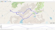
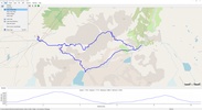
In addition to being able to place on a map all the GPS locations that we have been visiting on a route, it is also capable of showing us other data such as elevation, pulse, cadence, temperature, gear changes, etc. On the routes it is also possible to display points of interest, and it is possible to display several routes at the same time.
When we open a route, we can choose the type of map we want to use. Natively, the program supports OpenStreetMap, the most widely used thanks to its openness. We also found 4UMaps, OpenTopoMap, USGS Imagery and USGS Topo. If we have another map, we can also add it.
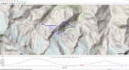
At the bottom of the program we can see the elevation gain and loss over the duration of the route. If we click on the elevation zone, the zone of the route in which that point is located appears, which is ideal to know the most complicated points of a route.
Therefore, if you want a program to be able to visualize routes accurately on your computer, do not hesitate to download GPXSee.
Comments
There are no opinions about GPXSee yet. Be the first! Comment